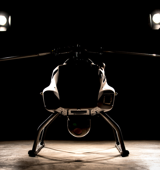
SKELDAR V-200. India’s first rotary unmanned UAV
V-200 is the first rotary winged medium-range UAV that can be operated from a tailored control station.
Equipped with multiple capabilities including surveillance and 3D mapping, the aircraft provides an edge in any environment – day or night.
Best of the Best
Skeldar is a Joint Venture between UMS Aero of Switzerland and SAAB of Sweden. The combination of UMS Aero and Saab’s leading edge capabilities deliver advanced solutions to meet complex challenges.
First of its kind in India
3F Advanced Systems, India, has recently partnered with Skeldar, in a first of its kind rotary wing 3F UAV partnership in the subcontinent, as part of the ‘Make in India’ technological development/transfer programme.
Real-time information
The system can hover for hours while providing real-time information to a control station or to a remote video terminal.
Eye in the Sky. Eye in the Sea. Anytime. Anywhere.
Launched from historically difficult locations such as the deck of a ship, a travelling convoy or other small stationery areas, Skeldar V-200 is designed to provide real time intelligence and surveillance as a force multiplier for land, civil security and maritime applications.
Skeldar V-200 enhances force capabilities by improving situational awareness. The platform combines short deployment and turnaround time with mobility and a modular design. This allows fast and efficient preparation, transportation and delivery of the system.
Utilities
- Emergency Response
- Search & Rescue
- Anti-Naxal Operations
- Disaster relief & post disaster assessment
- Police Response Coordination
- Boarder/ Coastal Surveillance
- Special Operations
- Environment Hazard assessment
- Wildlife & Habitat Monitoring
- Site Analysis & Design Planning
- Terrain Mapping
- Power Grid Survey
- Exploration (Oil, Gas & Minerals)
- Aerial Photography


Unmatched technology, making it more than an aircraft.
The compact solution is fully autonomous, controlled by high-level-commands such as “Point and Fly” and “Point and Look”.
With its agile and readily deployable flight performance compared to other compact fixed-wing UAV systems, Skeldar V-200 gets closer to the action, keeping one step ahead.

Availability
Fully autonomous Vertical Take-Off and Landing (VTOL) and hover capabilities provide the operator with enhanced usability and maximum time in the air.

Ease of Operation
Fully integrated into existing systems, Skeldar V-200 ground control station features an intuitive man-machine interface and requires minimal operator input. The system incorporates fly-home and safe landing modes.

Cost Efficiency
Developed with a low lifecycle cost in mind, the modular design enables system customisation and functional development, with air maintenance carried out at unit level. Compartments can be easily accessed for service, maintenance and payload reconfiguration.
 Multiple Payload Capacity
- Easy Deployment – No Airfield needed
- Fully automated Vertical Take-off and Landing
- Maritime Ready
- Heavy Fuel Engine
- Point-and-Fly and Point-and-See principle
- Tethering Mode supporting moving UCS
- Single or dual operator setup
- Redundant flight safety critical components
- Open interface to BMS and C4ISR system
- STANAG 4586 compliant
- Cost & Resource Effective surveillance solution for Defence and Para-Military Forces
- Flexible short term/ Long term Dry/Wet lease options
- Compressing the Decision Loop by accurate Surveillance
- Assured 80% aircraft serviceability and availability.
- Multiple mission availability with credible payload options
- Rapid Deployment to meet immediate threats & challenges

Physical
- Rotor diameter 4.6 m (15 ft)
- Airframe lenght4 m (13 ft)
- Height1.3 m (4.2 ft)
- Width1.2 m (4 ft)
- MTOW235 kg (518 lbs)
Performance
- Endurance 5+ hours (Subject to size of fuel tank module and payload configuration)
- Mission radius 90 km (54 nm) (with Dual Redundant Command and Control Link)
- Service ceiling 3000 m (10 000 ft)
- Max air speed140 km/h (75,6 kts)
- Fuel Heavy Fuel (Jet A1, JP5, JP8)
- Temperature Range -30° C / +40° C

System Configuration
- 2 x Air Vehicles
- Full Avionics System
- 1 x Ground Control Stations (GCS)
- Integrated Air Data Terminal (ADT)
- Redundant C2 and Encrypted Data Link Integrated Autopilot
- Flight Management Software
- Training Package
- Full Operations and Maintenance Manuals
Multiple Payload
“Bridging the Gap – Intelligence to Action”
- Flexible, Multiple Payload options
- EO/IR Gimbal
- HD Camera
- LIDAR
- Visual Detection and Ranging (ViDAR)
- GMIT + SAR RADAR
- Pollution Monitoring Payload
- Hyper-spectral Payload
- AIS
- SWIR Camera
- ESM Payload
- SH/DF Direction Finder
Typical Payload Options
Skeldar is a versatile system for a wide range of applications such as reconnaissance, identification, target acquisition and electronic warfare. A number of COTS high resolution EO/IR, SAR and EW sensors are available.

EO/IR
Electro-Optical/Infrared (EO/IR) gimbals provide advanced wide-area situational awareness and intelligence gathering through collection, identification, categorization and geo-location of static and moving objects of interest. It provides real-time, high-definition video to commanders and decision makers for uninterrupted surveillance of borders, urban areas, activity and events both by day and night.
Radars GMTI/SAR
Synthetic Aperture Radar (SAR) is a radar system that uses the flight path of the platform to simulate an extremely large antenna or aperture electronically and generates high-resolution remote sensing imagery. SAR is used to create images of an object, such as a landscape. These images can be 2D or 3D representations of the object. High-resolution SAR provides true, all-weather ground mapping and surveillance imaging, as well as Ground Moving Target Indication (GMTI).


Lidar
Laser Imaging Detection and Ranging (LIDAR) is a remote sensing technology that measures distance by illuminating a target with laser and analyzing the reflected light. LIDAR for 3D geographic survey systems provides geologists and mapping professionals with the ability to examine both natural and man-made environments with more accuracy, precision and flexibility, and to produce highly accurate maps and digital elevation models for use in geographic information systems.

Ease of Operation on Decks
Maritime operations, from civilian to military, require robust and dependable intelligence.
Increasingly Remotely Piloted Aerial Systems (RPAS) strategies have become central to successful maritime missions. SKELDAR provides a range of Unmanned Aerial Vehicles (UAVs) suited to seaborne activities including Vertical Take Off and Landing (VTOL) rotary platforms. Multi-role, we are uniquely positioned to advise customers on the appropriate platform for their needs.
Search & Rescue
Smart Thinking Makes a Difference
From high profile disaster recovery and rescue missions to co-ordination of land, sea and air assets, we are ideally suited to support customers in civilian and security agencies tasked with implementation of Search and Rescue (SAR) missions. Our multi-platform portfolio, with Ground Control Station (GCS) support from air, sea or land assets (or a combination) provide optimised co-ordination.


Anti-Piracy
One Chance to get it Right
Proven on anti-piracy missions worldwide, including the Indian Ocean/Horn of Africa through to South East Asia and elsewhere, our Unmanned Aerial Vehicles (UAVs) provide duration and the in the air intel. It is difficult and dangerous situations such as these where speed and covert operations can spell the difference between success and failure.
Map in the picture depicts Armed Robbery & Piracy Against
Ships in 2014

Intelligence Surveillance
SKELDAR has its own avionic solutions which serve to fly various types of Unmanned Aerial Vehicles (UAVs) simultaneously on the same Ground Control Station (GCS). We can provide customers with qualified ISR (Intelligence, Surveillance and Reconnaissance) instructors for training of vehicles or to interpret sensor information alongside a Remotely Piloted Aircraft Systems (RPAS) capability requirement.
SKELDAR offers multi-day ISR courses to suit your needs, led by professionals with years of experience in the frontline. Available for both military and non-military personnel, each course puts you in the driving seat with real-life scenarios.
Tactile Law Enforcement
Unmanned Aerial Vehicles (UAVs) are becoming the go-to technologies operated by Border Protection officers across the world to survey their land and uphold the security of their own border.
Hostile border territories present a tough challenge for security teams, with sites of intense confrontation between law enforcement and law evasion leading to a threat in human lives. Using UAVs to survey the border eliminates 90% of the risks involved on land, and additionally, is far more efficient and accurate, covering infinitely more ground than is possible by current methods.


Moving target locked
SKELDAR include a radar mode of operation to identify a moving target. Once locked, the platform can tail and send real-time information to its bespoke Ground Control Station (GCS). The ability to receive real-time information without risking personnel on the ground gives your team an edge in any environment.
Laser mapping through the noise
Our platforms are designed with state-of-the-art solutions including LiDAR (Light Detection and Ranging) to distinguish targets. LiDAR uses advanced methods to send laser pulses in certain areas, detecting the speed of reflection to recreate and map boundaries on land.
Airborne Light Detection and Ranging, or LiDAR, is revolutionising the way many industries gather data. With applications from pipeline, transmission line and highway and railway corridor surveys to coastal, forestry and flood plain surveys, LiDAR, or laser mapping, has the ability to penetrate difficult to access areas quickly and efficiently.


Security is the main Priority
Government and military officials are tasked with keeping a step ahead in order to tackle crime, reduce threat and maintain security.
3FAS is a multi-skilled enterprise with all the capabilities necessary to manage and deliver total Unmanned Aerial Vehicle (UAV) programmes to a wide variety of security sectors globally.
Developments in UAV technologies have made it both easier and more cost-effective to utilise these new technologies, becoming the number one requirement in industries such as border control and security.

Making infrastructure
Many organisations have invested heavily in deploying large infrastructure across an expansive geographic network, maybe even spanning countries and continents (for example power lines, mobile phone towers, bridges, oil pipelines). Infrastructure must be routinely inspected to not only ensure its structural integrity for continuing safe operations but also to monitor for intruders and other potential trespassers.
Traditionally, inspections have been completed by deploying teams of people. However, these types of examinations often entail high risk situations and very long journeys requiring each team member to spend a long time in the field.
UAV technologies
Airborne Light Detection and Ranging (LiDAR) is revolutionising the way many civilian industries gather data. With a wide range of applications from pipeline, transmission line and highway and railway corridor surveys to coastal, forestry and flood plain surveys, LiDAR, or laser mapping, has the ability to penetrate difficult to access areas quickly and efficiently.
At 3FAS, each platform is LiDAR enabled to cover any area, eliminating the danger of manned crews becoming subjected to difficult terrain or not being able to travel across survey areas.


Tackle deforestation
SKELDAR provides a range of platforms to help monitor forests and woodlands and gather important data quickly and efficiently to make decisions fast.
Forests and woodlands are among the most biodiverse and valuable terrestrial ecosystems on the planet. The world’s natural forests and woodlands are shrinking due to the impacts of climate change and many years of deforestation. Causes include agribusiness, illegal logging, mining, building new roads and more recently an increase in hydroelectric dams.
Skeldar Improves Agricultural Data Delivery
With an Unmanned Aerial Vehicle (UAV), such activities as crop control and the tracking of animals are made efficient with precision targeting at a fraction of the time taken by traditional methods. At 3FAS, we have a variety of platforms to help monitor the vast lands in question.


Wildlife conservation techniques
Wildlife Conservation involving the protection of plant and animal species and their habitats is a priority across hotspots worldwide. Increasingly Unmanned Aerial Vehicles (UAVs) and Command, Control, Communications, Computers, Intelligence, Surveillance and Reconnaissance (C4ISR) strategies are helping government agencies and non-governmental organisations (NGOs) to implement policies designed to protect wildlife.
3FAS brings the technology to gather the required data to help concerned agencies to make quicker and more informed decisions